
Last updated on January 25th, 2026 at 03:54 pm
South Australian Planning Portal Application (SAPPA) Bushfire hazard layers
SAPPA provides information which affects property development and planning. This includes alerting potential home buyers and developers of the bushfire risk in areas of South Australia. The diagram below provides a bushfire hazard overview of the Fleurieu and Mt. Lofty Ranges. It indicates that a large portion of the Mt. Lofty Ranges and Fleurieu are high risk areas for bushfire. In contrast, it also shows that areas to the north and west of Mt. Lofty Ranges and the Fleurieu have a medium or general bushfire risk.

The specific fire risk of an area such as Mount Compass can be provided by selecting the community and applying overlay filters.

The area in red indicates high risk compared to the centre of town which has two areas of medium risk, one in the downtown or central business district (CBD) and another on on the west side of Sandmine Rd.
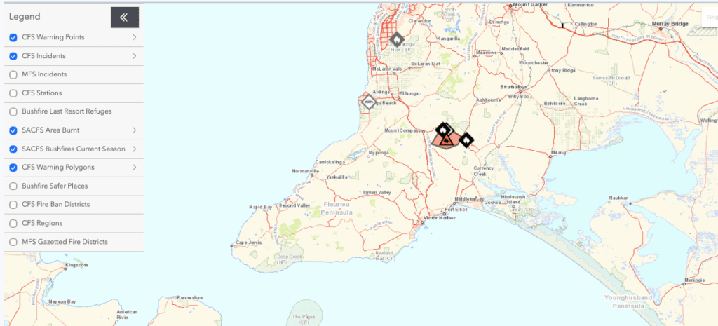
Current notification of bushfires
https://cfs.sa.gov.au/warnings-restrictions/warnings/incidents-warnings.jsp
Current warnings and incidents of bushfires across South Australia are provided by the South Australian Country Fire Service (CFS). Below is an image of the bushfire warnings and incidents for Mount Compass area on Sunday 18th January 2026. The webpage allows the setting of information which includes warning points and areas under threat of bushfire. There is a smart phone app available entitled Alert SA, which can provide the same information in a portable format. Visit the website for more information.
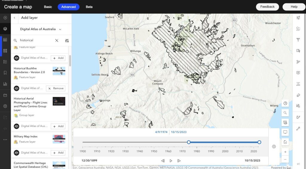
Historical Bushfire Boundaries from the Digital Atlas of Australia
The Digital Atlas of Australia has an overlay which provides a graphical mapping of historical bushfires boundaries dating from 1899 to 2023. The overlay can be filtered to provide visual evidence of bushfires which have occurred in the vicinity of a given community or council area.
Bushfires in the Mount Compass vicinity from 1899 to 2023
In the image below historical bushfire boundaries appear in Yundi, Cleland Gully, and a much larger bushfire which covered a significant area north east of Hope Forest and Tooperang. Clicking on the surface of the area provides additional details about the bushfire. For example, the Cleland Gully bushfire was registered in the database in 2019 and the larger bushfire occurred in 1983.
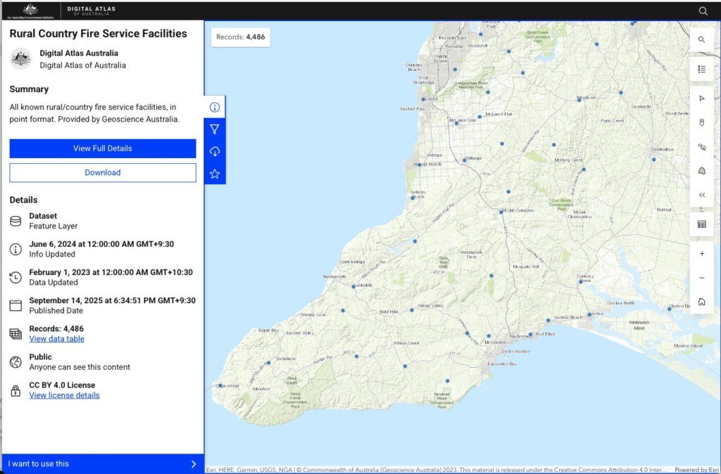
Rural Country Fire Service Facilities
The Digital Atlas of Australia also supplies information about the physical location of Rural Country Fire Service facilites. The image below shows the fire service facilities in the vicinity of Mount Compass. Clicking on the blue dots generates a table which provides further information about the specific rural country fire service.
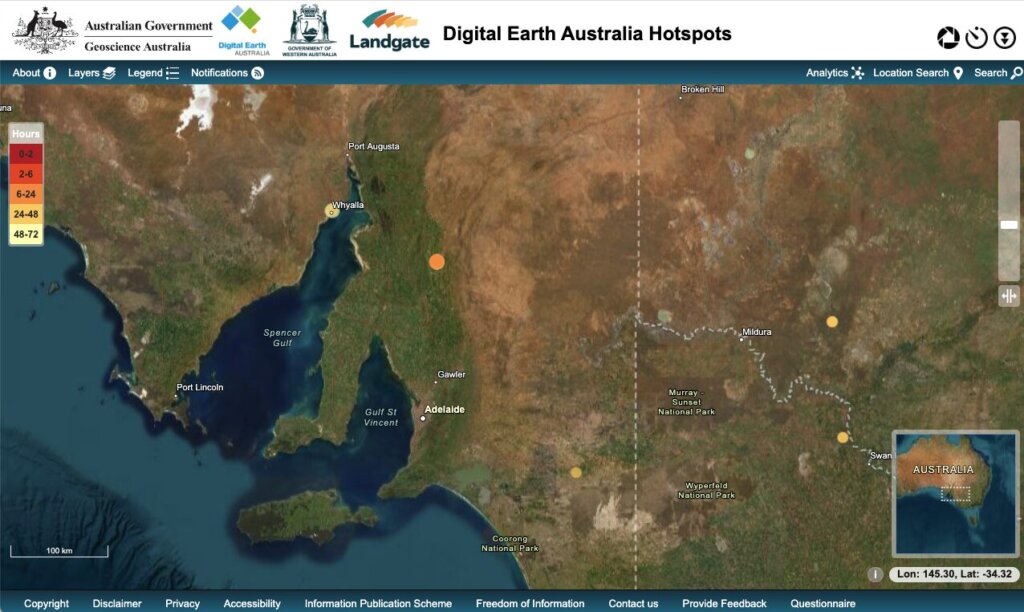
Digital Earth Australia Hotspots
https://hotspots.dea.ga.gov.au
Digital Earth Australia Hotspots is a free mapping tool developed by Geosciences Australia. It uses data from satellites to identify hotspots, areas within the Australian landscape. As the satellites orbit the Earth, they will continuously sweep past to build up a profile of the hotspot to ascertain if it is a potential bushfire.
Digital Earth Australia Hotspots is a national bushfire monitoring system that provides timely information about hotspots to emergency service managers and critical infrastructure providers across Australia. Updated with new information every 10 minutes, the mapping system uses satellite sensors to detect areas producing high levels of infrared radiation (called Hotspots) accurately to allow users to identify potential fire locations with a possible risk to communities and property. (Geosciences Australia | Digital Earth Australia Hotspots: About)
In the image below, satellites have captured three hotspots at Whyalla, north west of Burra in the mid-north and the last near Lameroo . Clicking on the hotspot can reveal the percentage likelyhood the hotspot is a potential fire. The hotspot at Whyalla is most likely heat from the steel mills.
Related topics
References
- Australian Government 2025, Digital Atlas of Australia, viewed on 4 December, 2025, <https://digital.atlas.gov.au>. This is the official website of the Digital Atlas of Australia, a mapping tool for overlaying information from Australian Government datasets.
- Government of South Australia 2024, South Australia Fire and Emergency Services Act 2005. This page contains a link to the current legislation, a 94 page PDF, which is the current l governing the South Australian Fire and Emergency Services.
- Government of South Australia 2021, SAPPA, viewed on 9 October, 2021, <https://sappa.plan.sa.gov.au/>. This is the planning portal for South Australia, which provides information about land zoning and principally subdivision.