
Last updated on March 3rd, 2026 at 11:09 pm
The Mount Compass area resides in a geological region defined as the Cape Jervis Formation. The South Australian Resources Information Gateway (SARIG) provides digital access to the South Australian geological information through the use of mapping tools and an online catalogue of reports.
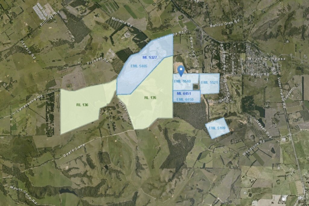
Using SARIG mapping tools, and selecting Mount Compass as a target location of interest, you can visualise the community and surrounding sandmine activity. Information about the physical environment is stored in data layers. One useful layer shows active mining tenements: Mineral Tenement Production layer.
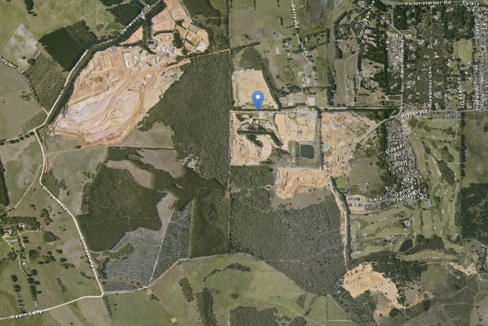
Mount Compass and surrounding sandmine activity
The brown scars to the west of Mount Compass (seen to the right) show sandmining activity.
Applying the Mineral tenement production layer
The Mining Tenement Production layer, when applied, reveals the Extractive minerals leases (EML), Mineral leases (ML), and Retention leases (RL). EML and ML leases are show active sandmining. RL refer to leases which can potentially be exploited. See Types of mining tenure for definitions of tenure types.
Mining Register Search – Tenements
https://mers.dem.sa.gov.au/mining-register/search-tenements
The Mining Register is a database which stores information about mining tenements. It is part of the Mining Exploration and Regulation System (MERS).
The new portal provides a modern digital platform to better meet the needs of community, industry and the department, streamlining regulatory processes, improving user experience, and supporting efficient interactions between industry and government. (Government of South Australia | Mining Exploration and Regulation System (MERS).
How to use the tenement register
You can use the database to look up the operators of the tenements. In the case of Mount Compass, the following tenements are listed in the register (as of 9 November 2025):
| Tenement code | Company owning the licence |
| ELM 5521 | Sand and Loam Pty. |
| ELM 5199 | Sand and Loam Pty. |
| ELM 6450 | Sand and Loam Pty. |
| ELM 5540 | Springvale Estates Pty Ltd |
| ELM 5465/ML 5327 | Holcim (Australia) Pty Ltd. |
| RL 136 | Holcim (Australia) Pty Ltd. |
| RL 135 | Holcim (Australia) Pty Ltd. |
Each Tenement Registry entry, contains details about the tenement contract. Additionally, using Australian Business Register, it is possible to find out more detail about the operators which are mining sand in Mount Compass.
The SARIG Catalogue also allows searches for printed information such as reports. The report discussed below provides useful insights into value of Mount Compass for sand extraction.
SAND RESOURCES OF THE MOUNT COMPASS AREA, RECONNAISSANCE DRILLING AND TESTING
Pain, A, Shaw, R, Valentine, J 2021, Sand resources of the Mount Compass area- Report book 99/00028,Government of South Australia, Adelaide.
This PIRSA publication in 1999 provides an analysis of the potential of the Permian sands around Mount Compass for commercial exploitation. Of particular interest is the analysis of drilling sites which provide information about the type of sands identified by their capacity to serve industrial use. Many of the commercial references provided in the report may not current as are the tenements under exploitation.
GEOLOGICAL SETTING
The Report provides details about the profile of the geology occupying the Cape Jervis formation including the surface sediments which make up the surface layer of Mount Compass.
The oldest rocks in the area are Palaeoproterozoic gneisses of the Myponga Inlier which are exposed in the prominent outcrops of Mount Moon and Mount Compass in the centre of the study area. (Figure 2). These rocks, together with Adelaidean and Cambrian sedimentary rocks to the northwest and east of the area comprise “basement” to the sand deposits. Glacigene sediments of the Cape Jervis Formation which are widespread on Fleurieu Peninsula fill steeply incised glacial valleys to depths of about 200 m in the Mount Compass area. These sediments which consist mainly of fine to medium grained sands were deposited by meltwater as Permian glaciers retreated easterly near the end of the Permian glaciation. The Permian sands were re-worked during Tertiary times, and the Tertiary sands generally have higher clay and iron contents than the relatively clean Permian material. Remnants of iron cemented lateritic cappings are present in places above the Tertiary sands. Permian sands, having high permeability and porosity, are an important aquifer at Mount Compass. The water table is near ground surface in low lying, boggy localities throughout much of the area.
Regolith exposed in roadworks cut away
The video below provides an indication of the type of surface soils and regolith which cover the surface of Mount Compass.
Water security in the Mount Compass area
Communities and businesses rely on the Permian sand aquifers for safe drinking, industrial and irrigation water supplies. In 2025, the Department of the Environment and Water provided a factsheet on the water security, which demonstrated that the sand distribution is spread unevenly across the region with significant variation in the depth of one part of the aquifer to another. There is one graphic which shows a cutaway profile of the section of the aquifer which supplies SA Water being significantly deeper than the one supplying patrons of the Golf Course Estate.
References
- Government of South Australia 2023, Sarig Map, viewed on 7 April, 2023, <https://map.sarig.sa.gov.au>. This graphical search tool allows tenement searches.
- Australian Government 2023, Current details for ABN 76 460 256 930, viewed on 7 April, 2023, <https://abr.business.gov.au/ABN/View?abn=76460256930>. This is the ABN listing for The trustee for Mt Compass Sand & Loam Unit Trust.
- Australian Government 2023, Current details for ABN 87 099 732 297, viewed on 7 April, 2023, <https://abr.business.gov.au/ABN/View?abn=87099732297>. This is the ABN listing for Holcim (Australia).
- Government of South Australia 2023, Current details for ABN 79 007 742 958, viewed on 7 April, 2023, <https://abr.business.gov.au/ABN/View?abn=79007742958>. This is the ABN for Springvale Estates Pty.
- Government of South Australia 2023, Glenshera Sand Glass Mine, viewed on 7 April, 2023, <https://www.energymining.sa.gov.au/industry/minerals-and-mining/mining/major-projects-and-mining-activities/major-operating-quarries/glenshera-sand-mine>. This page provides information about the Glenshera mining operation, which is listed as a major mine.
- Government of South Australia 2025, Mining Register Search – Tenements, viewed on 7 April, 2023, <https://mers.dem.sa.gov.au/mining-register/search-tenements/>. This page operates as an interface to the Mining Register database.