
Land system reports
The Department for Environment and Water of South Australia has published a set of land system reports which identify landscapes with a specific soil grouping which can aid in understanding regional variations in vegetation and potential for human land use.
Description of the Land Systems
Land Systems (based upon groupings of Soil Landscape Map Units) are broad and readily recognisable landscape areas defined by particular and distinctive patterns of land use, geology, topography, soils and vegetation within a limited climatic range. A Land System Report is available for each Land System. (Government of South Australia | Land Systems of Southern South Australia).
Each land system report is named after a region or town in which the soil landscape is represented. An example of a land system report is the Mount Compass land system report. Each report is identified by a three digit code. In this case, MCO is assigned to identify Mount Compass land system.
Land systems are not singular soil descriptions but identify the landscape in which a range of similar types of soils exist. Each of the soil types are referenced by a secondary three digit code indicating soil landscape units (SLUs). These units identify the aspects of the soil and other characteristics such as the land relief. In each SLU, specific two/three digit soil identifier represents a soil type.
In the MCO system, there are 37 Soil Landscape Units (SLUs) mapped in the Mt Compass Land System, each of which has a set of soil profiles. For example, the old part of the town of Mount Compass has the SLU code of PrD. The soil profile is descriptive including providing its topography and overall soil productivity for agricultural use.
At the end of the Land System Report is a list of soil profiles which provide more detail about the composition, depth and geological origins of the soils. They also relate to the Australian Soil Classification. The main soil classifications include:
See Australian Soil Classification, for an expanded discussion on soil classifications.
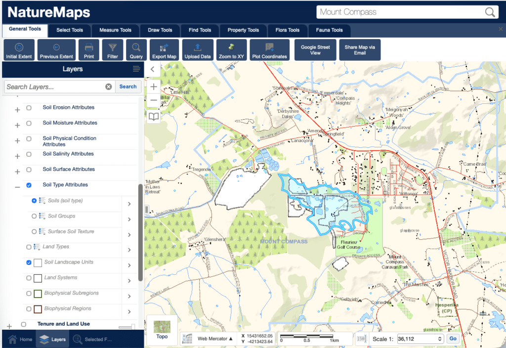
The main Soil Landscape Units (SLUs) within and immediately around the town of Mount Compass
There are five SLUs which are evident in the town of Mount Compass. They include: MCOPrD, MCOPrC, MCOLKB, and finally MCOPxA. Using NatureMaps, it is possible to view the physical topography of the SLUs by applying the soil layers. The graphic below displays the results of selecting the soil layer, the Soil Type Attributes sublayer, then Soil Landscape Unit sublayer. Clicking on the Mount Compass geometry yields SLU zones.
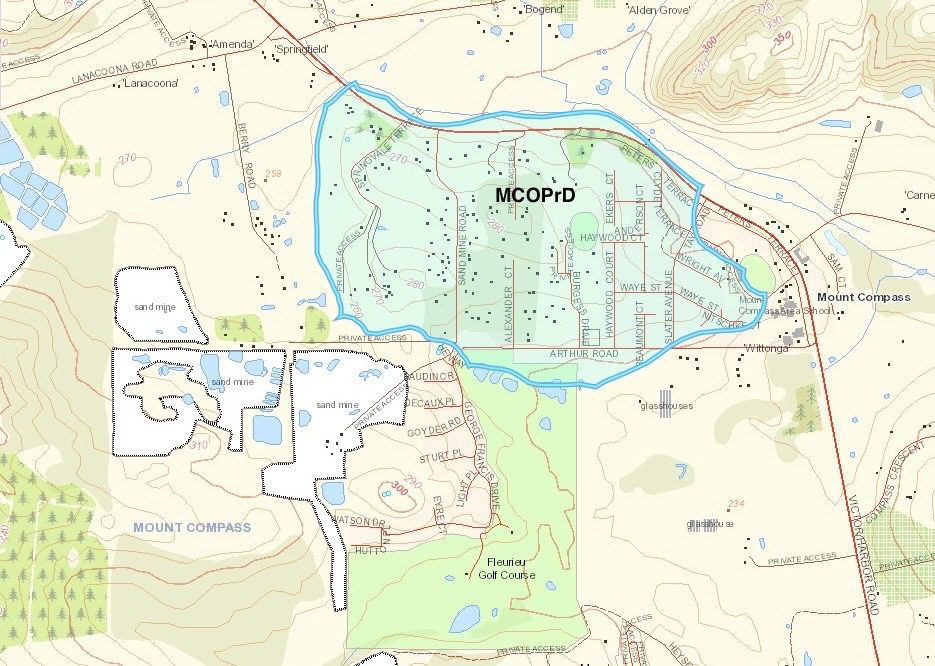
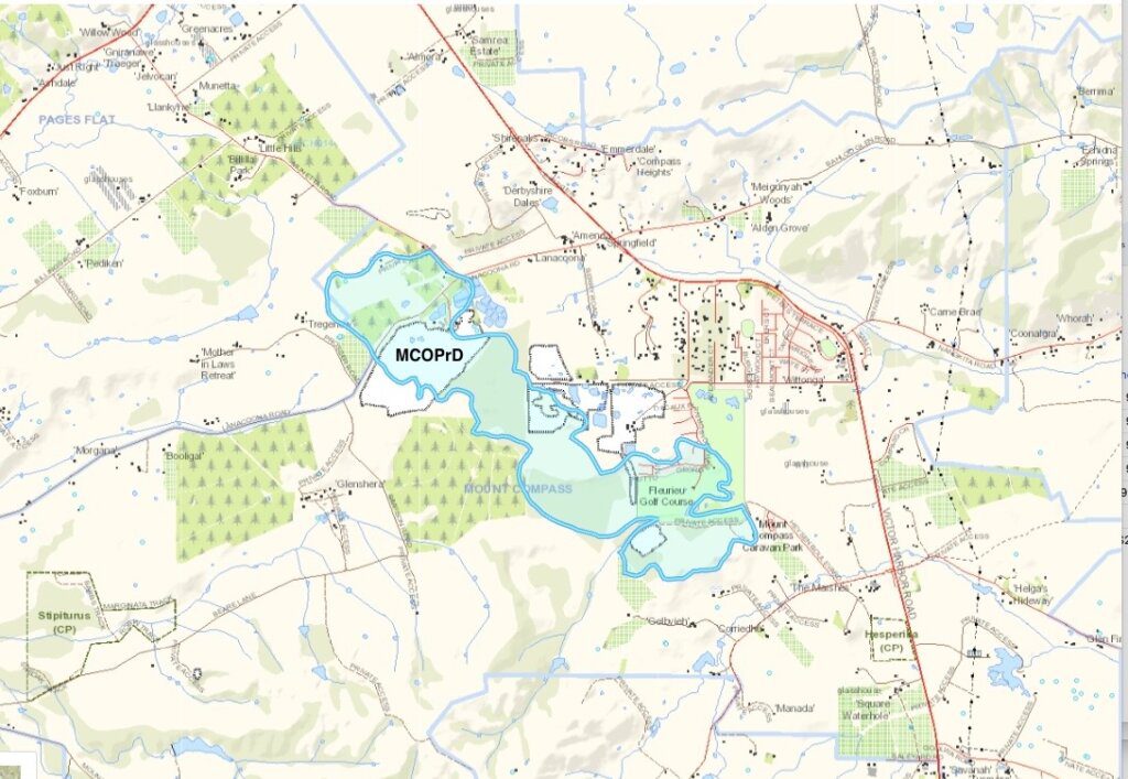
MCOPrD
The Soil Landscape Unit summary table in the report, indicates that 3.9% of the entire land system contains this soil profile. The graphic below illustrates that this unit occupies most of the original town area including the territory between Sandmine Rd and Arthur Rd, with its northern border of Victor Harbor Rd.
Slopes and rises formed on sandy glacial sediments (partly reworked), with slopes of 2-20%. Soils are predominantly sandy. Main soils:
- Bleached siliceous sand – H3a (E)
- Sand over acid clay – G5
- Imperfectly drained highly leached sand – I2a (L)
- Highly leached sand – I1 (L)
- Wet highly leached sand – I2b (M) on lower slopes
(MCO Land System report)
Agricultural potential
Soils are all characterized by leached highly infertile and acidic sandy surfaces. Impeded drainage is a problem in places. Water repellence can also be a problem in some seasons. Productive potential is low, although results can be achieved with intensive nutrition management. (MCO Land System report)
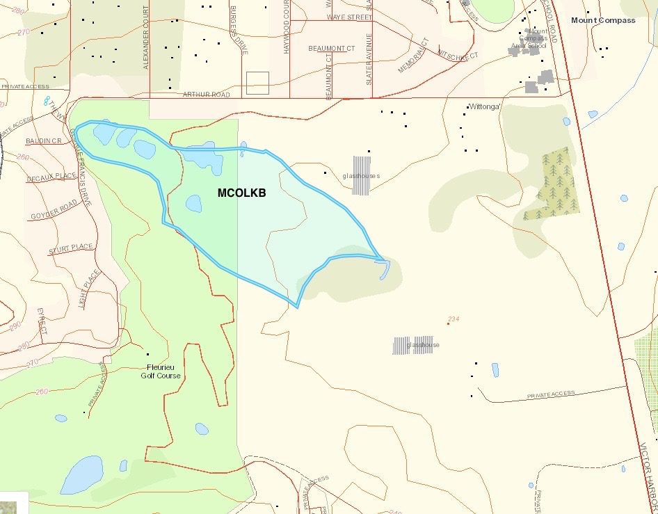
MCOLKB
The Soil Landscape Unit summary table in the report, indicates that 0.2% of the entire land system contains this soil profile. The graphic below illustrates that this unit occupies most of the original town area including the territory extending from the corner of George Francis Drive and Arthur Rd diagonally eastward where the Mount Compass Golf Course resides. This area was at one time the site of a sand mine and is currently part of a golf course. The original recorded soil profiles have been most likely modified by human activity.
MOCLKB soil profile has a slope of less than 2%. The soils are highly variable, reflecting the source areas of the parent sediments. Most soils have sandy to loamy surfaces over mottled clay subsoils. Main soils:
- Thick sand over sandy clay – G3b (E)
- Loam over brown clay – F1b ©
- Sandy loam over poorly structured brown clay – F2 (L)
- Deep bleached siliceous sand – H3b (L)
- Wet highly leached sand – I2b (L)
- Bleached loamy sand over sandy clay loam – M1 (M)
(MCO Land System report)
Agricultural potential
Soils are deep but poorly drained due to tight clayey subsoils and lower slope position. Fertility is moderate to low depending on sandiness of surface soil. Most are acidic.
(MCO Land System report)
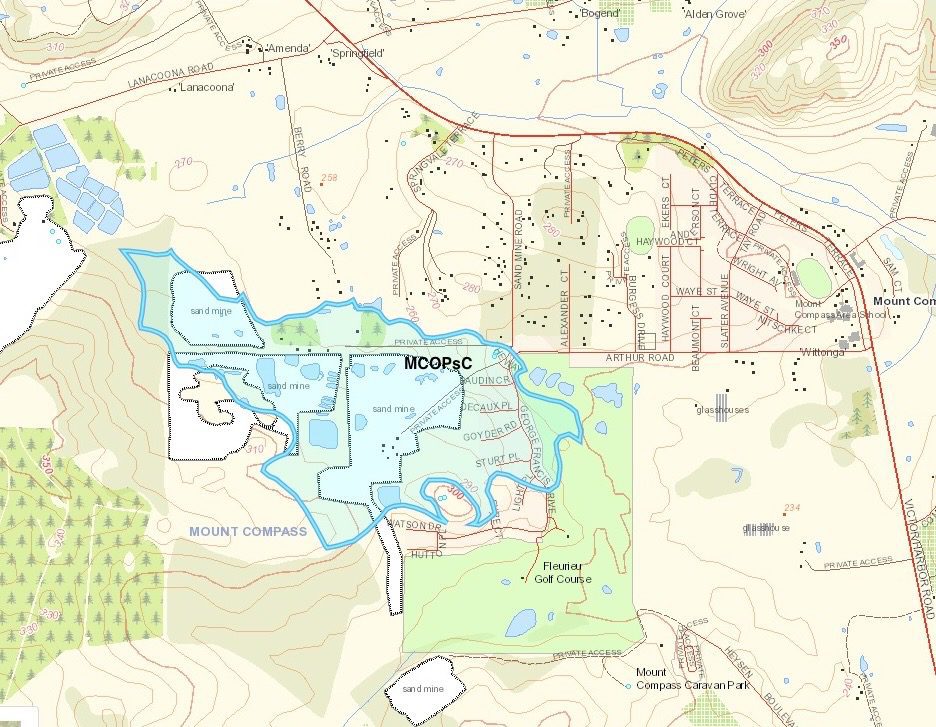
MOCPsC
The Soil Landscape Unit summary table in the report, indicates that 0.2% of the entire land system contains this soil profile. The graphic below illustrates the area with the PsC soil profile, occupying the south west suburb including George Francis Drive to the east and extending west covering three active sand mines.
The PsC profile represents 22.7% of the landscape profiles of the MCO land system. It is related to two other profiles (PsD and PsF).
The soils are almost all very sandy and strongly leached. The most common soils have clayey subsoils forming in soft sandstone. Other types include deep sands and sand over coffee rock, overlying a variety of materials from sands to clays. Main soils:
- Sand over acid clay – G5 (E) on slopes
- Bleached siliceous sand – H3a (L) on slopes
- Highly leached sand – I1 (L) on slopes
- Sandy loam over brown clay on weathered rock – F1/K4 (M) on slopes
- Imperfectly drained highly leached sand – I2a (M) on slopes
- Thick sand over sandy clay – G3b (L) on lower slopes and flats
- Wet highly leached sand – I2b (M) on lower slopes and flats
It is characterised by undulating rises to rolling low hills formed on massive sandy till, sandstone, windblown sand and associated outwash sediments. Slopes on rises are as low as 3% with relief of less than 30 metres, and on low hills slopes are up to 25%. The landscapes also include slopes of variable gradient abutting the sides of the ancient glacial valleys. The landscape has a rounded appearance broken by narrow poorly drained watercourses, swampy depressions and ferricrete (ironstone) hilltops. Larger occurrences of these latter features are mapped out as PxA/PxB/PxE, LMA/LME and FhZ respectively. (MCO Land System report)
Agricultural potential
These soils are sandy, naturally infertile and highly susceptible to acidification. Water repellence can also be a problem in some seasons. Most of the soils are at least moderately deep and moderately well drained (except on lower slopes), so with adequate nutrition, productive potential is reasonable. (MCO Land System report)
MCOPrD
The Soil Landscape Unit summary table in the report, indicates that 3.9% of the entire land system contains this soil profile. The graphic below illustrates an area extending from north of Lanacoona Rd encompassing a sand mine tenement on the north west side across to much of the southern golf course abutting a second sand mine tenement.
Slopes and rises formed on sandy glacial sediments (partly reworked), with slopes of 2-20%. Soils are predominantly sandy. Main soils:
- Bleached siliceous sand – H3a (E)
- Sand over acid clay – G5 ©
- Imperfectly drained highly leached sand – I2a (L)
- Highly leached sand – I1 (L)
- Wet highly leached sand – I2b (M) on lower slopes
(MCO Land System report)
Agricultural potential
Soils are all characterized by leached highly infertile and acidic sandy surfaces. Impeded drainage is a problem in places. Water repellence can also be a problem in some seasons. Productive potential is low, although results can be achieved with intensive nutrition management.
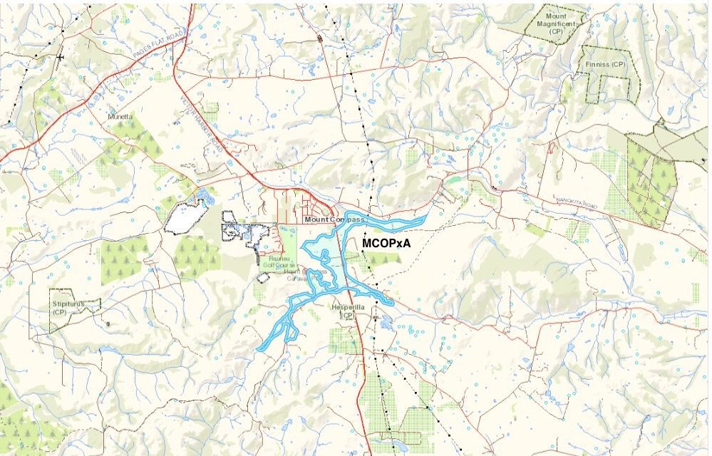
MOCPxA
The Soil Landscape Unit summary table in the report, indicates that 1.5% of the entire land system contains this soil profile. The graphic below covers the Tookayerta wetlands including the Mount Compass School swamp which is habitat for unique species of Australian flora and fauna.
Very gently inclined lower slopes, flats, drainage depressions and swales underlain by variable, but mainly coarse grained, outwash sediments derived from the erosion of hillside Soil Landscapes Ps* and Pt*. Slopes range from 0% to 4%.
PxA flats (flatlands) with slopes of less than 1%. The soils are mainly sandy in the surface, with variable subsoils including coffee rock, heavy mottled clay and sandier clay materials. Main soils:
- Wet highly leached sand – I2b (E)
- Thick sand over sandy clay – G3b (E)
- Bleached loamy sand over sandy clay loam – M1 (E)
(MCO Land System report)
Agricultural potential
Imperfect to poor drainage is the main feature of these landscapes. In addition, most soils have low natural fertility. (MCO Land System report)
What is the role of Department for Environment and Water?
The Department for Environment and Water aims to help South Australians conserve, sustain and prosper. To achieve our purpose we’ve adopted four complementary roles: A facilitator of community involvement in and taking responsibility for the environment. A steward of the state’s natural resources to enable sustainable development. The custodian of public parks, gardens, heritage places and crown lands for public benefit and enjoyment, and for their intrinsic value. An authority on the state’s environment and natural resources to help governments, businesses and individuals make good long-term decisions. (Data SA | Department for Environment and Water)
References
- Government of South Australia 2025, Land System Reports, viewed on 2 November, 2025, <https://data.environment.sa.gov.au/content/land-system-reports/forms/allitems.aspx>. This page provides a portal to a list of land system reports published by the Government of South Australia.
- Government of South Australia 2021, Mount Compass Land System report, viewed on 18 February, 2022, <https://data.environment.sa.gov.au/Content/Land-System-reports/MCO.pdf>. This PDF is a report on the types of soils in the Mount Compass region.
- Government of South Australia 2024, Nature Maps, viewed on 13 January, 2024, <http://spatialwebapps.environment.sa.gov.au/naturemaps/?locale=en-us&viewer=naturemaps>. This is the website is funded by the Ministry of Environment and Water and dedicated to information related to South Australian Nature.