
Last updated on August 30th, 2026 at 06:03 pm
Table of Contents
- Research
- Factsheets on the Messmate Stringybark woodland communities
- Short plant list for revegetation
- Finding the woodlands in your area of the Fleurieu
- Pre-European Distribution of Messmate Stringybark woodlands
- Pre-European Plant communities in Mount Compass area
- European Settlement
- Threat of habitat loss
- References
Research
The Messmate Stringybark woodland appears in south eastern Australia including in the Fleurieu peninsula of South Australia. The tree storey is dominated by Eucalyptus obliqua, commonly known as Messmate Stringybark.
Factsheets on the Messmate Stringybark woodland communities
Prior to 2025, the Department of the Environment and Water (DEW), produced two factsheets:
- A short plant list for home and commercial use. The list groups plants into woodland canopy: trees and tall shrubs; and types of understorey: medium and small shrubs, sedges and rushes, grasses, herbs, ground cover, and climbers. Many of the plants could be grown from seed and most were available in state, council, commercial and not-for-profit nurseries.
- A complete plant list contains a full inventory of plant species which matched Messmate Stringybark woodlands.
Short plant list for revegetation
Trees
- Acacia pycnantha | Golden Wattle
- Acacia melanoxylon | Blackwood
- Banksia marginata | Silver Banksia
- Eucalyptus leucoxylon ssp. leucoxylon | South Australian Blue Gum
- Eucalyptus obliqua | Messmate Stringybark
- Exocarpos cupressiformis | Native Cherry
- Eucalyptus cosmophylla | Cup Gum
Shrubs
- Acacia gunnii | Ploughshare Wattle
- Acacia myrtifolia | Narrow-leaf Myrtle Wattle
- Acacia verniciflua | Varnish Wattle
- Allocasuarina muelleriana ssp. muelleriana | Common Oak-Bush
- Bursaria spinosa | Bursaria
- Daviesia brevifolia | Leafless Bitter-Pea
- Daviesia leptophylla | Narrow-Leaf Bitter-Pea
- Daviesia ulicifolia | Prickly Bitter-Pea
- Epacris impressa | Common Heath
- Goodenia ovata | Hop Goodenia
- Grevillea lavandulacea ssp. lavandulacea | Lavender Grevillea
- Hakea carinata | Erect Hakea
- Hibbertia exutiacies | Prickly Guinea-Flower
- Ixodia achillaeoides ssp. alata | Hills Daisy
- Leptospermum continentale | Prickly Tea-Tree
- Leptospermum myrsinoides | Heath Tea-Tree
- Olearia tubuliflora | Rayless Daisy-Bush
- Platylobium obtusangulum | Holly Flat-Pea
- Pultenaea acerosa | Bristly Bush-Pea
- Pultenaea daphnoides | Large-Leaf Bush Pea
- Tetratheca pilosa ssp. pilosa | Hairy Pink-Bells
- Xanthorrhoea semiplana ssp. semiplana | Yacca
Sedges and Rushes
Grasses
- Austrodanthonia setacea | Small-flower Wallaby-Grass
- Austrostipa muelleri | Tangled Spear-Grass
- Austrostipa nodosa | Tall Spear-Grass
- Microlaena stipoides var. stipoides | Weeping Rice-Grass
- Themeda triandra | Kangaroo Grass
Herbs
- Arthropodium strictum | Common Vanilla-Lily
- Bulbine bulbosa | Bulbine-Lily
- Burchardia umbellata | Milkmaids
- Calostemma purpureum | Pink Garland-Lily
- Dianella revoluta var. revoluta | Black-Anther Flax-Lily
- Geranium solanderi var. solanderi | Austral Geranium
- Goodenia blackiana | Native Primrose
- Helichrysum scorpioides | Button Everlasting
- Lagenophora huegelii | Coarse Bottle-Daisy
- Leptorhynchos squamatus ssp. squamatus | Scaly Buttons
- Oxalis perennans | Native Sorrel
- Pelargonium australe | Austral Storks-Bill
- Ranunculus lappaceus | Native Buttercup
- Thysanotus patersonii | Twining Fringe-Lily
- Tricoryne elatior | Yellow Rush-Lily
- Wahlenbergia stricta ssp. stricta | Tall Bluebell
Ground covers
- Bossiaea prostrata | Creeping Bossiaea
- Kennedia prostrata | Scarlet Runner
- Scaevola albida | Pale Fanflower
Finding the woodlands in your area of the Fleurieu
DEW had developed NatureMaps, an online mapping tool for identifying the Pre-European vegetation plant communities throughout South Australia. Each of the woodlands were defined by NatureMap vegetation codes. In the case of the Messmate Stringybark woodlands, the vegetation code was: ML0101PE. This factsheet remains available online within the DEW web site and also at the Green Adelaide web site.
In 2025, the Landscape Board, Hills and Fleurieu, published a factsheet for each of the vegetation codes:
Each factsheet distinguishes clearly the plants in these distinct communities. They are a great deal more detailed; each providing information about:
- Community distribution in the Fleurieu in map format (See maps)
- Soil type, rainfall, and notes on revegetation
- A plant list separated into plant type: trees, shrubs, mat plants, sedges and tussocks, twiner/scramblers, and herbs
- Details for each plant including: whether plants can be purchased in a plant nursery, propagation methods, seed treatment, and seed propagation treatments, and level of difficulty for seed propagation, and how the plants are pollinated.
Pre-European Distribution of Messmate Stringybark woodlands
The distribution of both woodlands before European settlement in the graphics below (marked in green) shows the extent of each woodland.
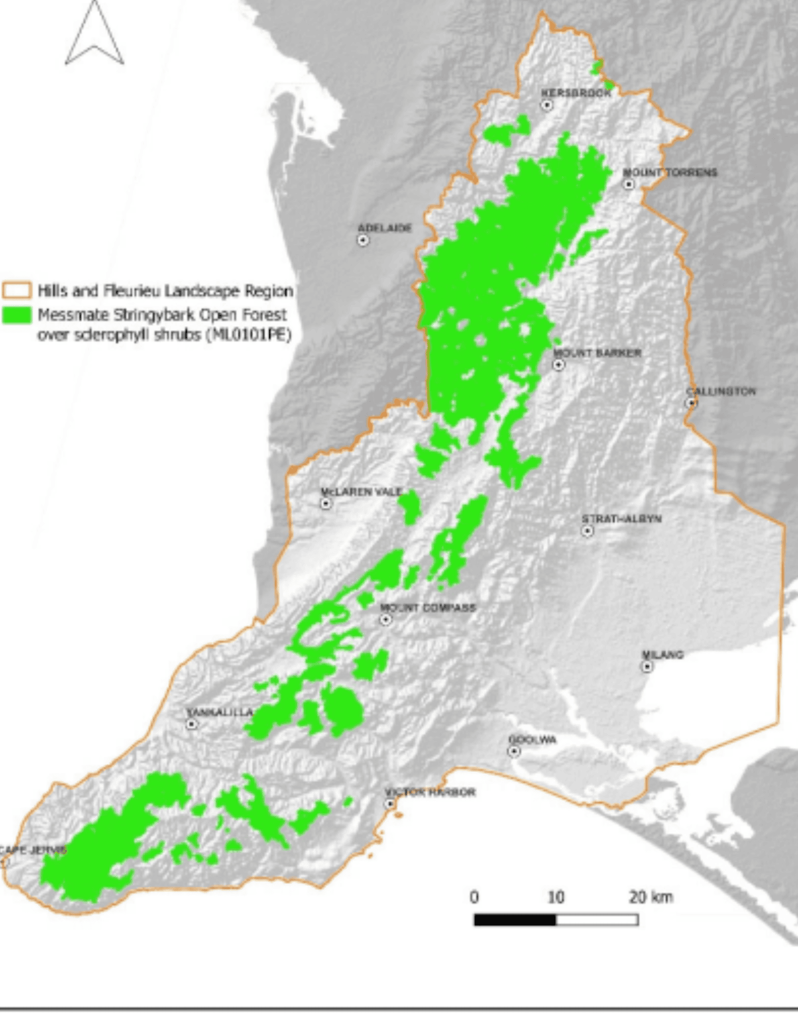
Messmate Stringybark (Eucalyptus obliqua) woodland (ML0101PE) distribution
Pre-European Plant communities in Mount Compass area
In the Fleurieu peninsula of South Australia, Messmate Stringybark woodland existed in the Mount Compass area. The image below was produced using NatureMaps, a free online tool provided by the Department of Environment and Water of the Government of South Australia.
Messmate Stringybark low woodland (ML0101PE)
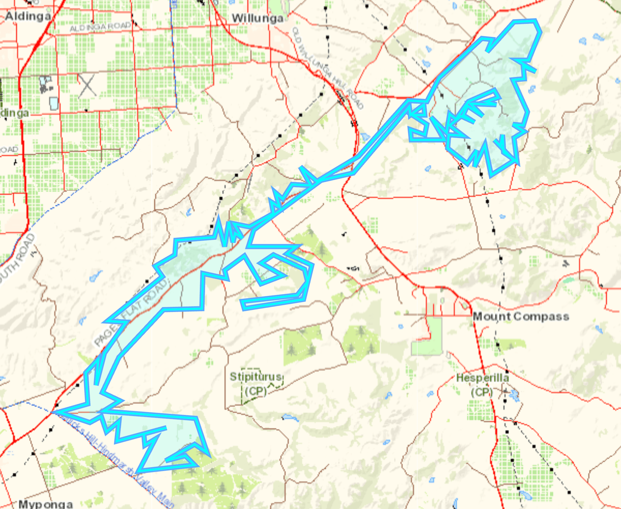
The Messmate Stringybark low woodland occurred along in parallel what is today Pages Flat Rd. crossing Victor Harbor Rd eastward along Brookmans Rd.
European Settlement
As European settlement encroached, firstly by draining swamps for growing vegetables, then clearing the lands with more fertile soils such as valley floors.
After much trial and error, between the 1920s and 1940s, both by farmers and agricultural advisors, the residents of the area learnt how to utilise these soils and make them productive pastures for some of the most productive dairy cattle in South Australia.
Anne Riddle, 1988, Chasing rainbows in the rain: A history of Mt. Compass, Nangkita, Tooperang and Yundi, Mt. Compass War Memorial Community Centre, Mount Compass. p. 10
Thus, the Messmate Stringybark woodlands yielded to dairy and meat production. The application of fertiliser and irrigation maintained production throughout the year. Pine plantations replaced woodlands as a source of timber and wind breaks. Pine trees do well in well-drained acidic soils.
Distribution today
The Messmate Stringybark low woodland (ML0101PE) is a fraction of its original pre-European distribution, approximately 20% remaining.
Of the approximately 49,400 hectares (ha) mapped as being present prior to European settlement, approximately 10,700 ha have been mapped in the Department of Environment and Water’s extant mapping layer (Data SA 2025).
Croft, S, Croft, T 2025, Messmate Stringybark (Eucalyptus obliqua) Open Forest over sclerophyll shrubs(ML0101PE).
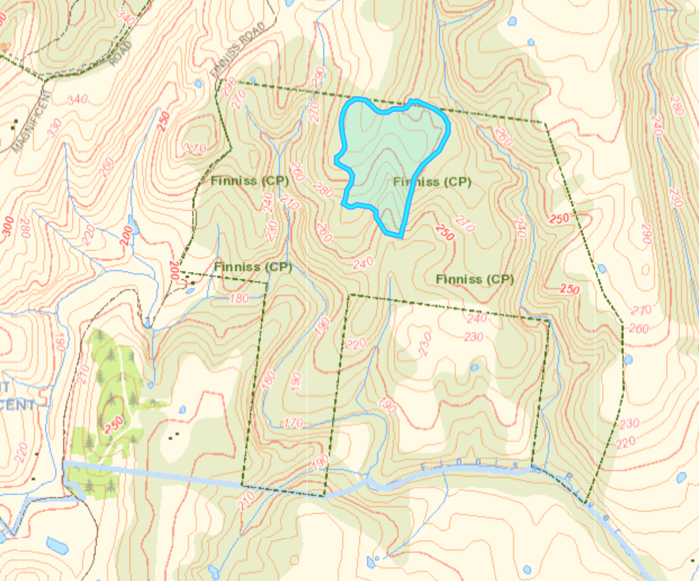
finniss conservation park
A Small area of messmate stringybark in close proximity to a Pink gum/Cup gum low woodland (ML2602PE) exists in Finniss conservation park.
Threat of habitat loss
The Landscape Board, Hills and Fleurieu (Landscape HF) is actively pursuing revegetation of areas to support the wildlife unique to Stringybark woodlands. Many of understorey plants can be grown from seed or seedlings or purchased from a Native nursery for private and public spaces. LIfestyle blocks and farms can plant canopy trees and understorey to support birds, bees and other native wildlife associated with Messmate Stringybark woodlands.
References
- Anne Riddle, 1988, Chasing rainbows in the rain: A history of Mt. Compass, Nangkita, Tooperang and Yundi, Mt. Compass War Memorial Community Centre, Mount Compass. p. 10
- Croft, S, Croft, T 2025, Vegetation Community Profile: Messmate Stringybark (Eucalyptus obliqua) Open Forest over sclerophyll shrubs (ML0101PE), viewed on 18 August, 2026, <https://hf.landscape.sa.gov.au/media/plant-species/ML0101PE-Messmate-Stringybark-Open-Forest-over-sclerophyll-shrub.pdf>. This 9 page PDF provides information about the plant community of the Messmate Stringybark open forest commissioned by the Landscape Board Hills and Fleurieu.
- Government of South Australia 2026, NatureMaps: Welcome to NatureMaps, viewed on 8 August, 2026, <https://data.environment.sa.gov.au/naturemaps/Pages/default.aspx>. This is the official website of Enviro Data SA, a service of the department of the environment, South Australia.
- Government of South Australia 2025, Stringy Bark (Eucalyptus obliqua) Open Forest, viewed on 16 August, 2019, <https://cdn.environment.sa.gov.au/landscape/docs/hf/b4w-species-list-h1-short-fact.pdf>. This 2 page factsheet contains a plant list based on the Messmate Stringybark open forest plant community.
- Nicolle, D. 2026, Eucalypts of South Australia 2nd Edition, Dean Nicolle.


